Tuesday 9 November 2010

Up the coast

The autumn has flown and we have now reached Bamburgh in two long linear walks from Craster. The blog below describes the first walk from Craster to Beadnell, a distance of 8 miles along the coast.

On a fresh bright day in early October we set off with Rob, our fri
end up from Wales . Craster village has many attractions: you can examine the small painted boats beached in the tiny harbou
r, buy kippers from the smokehouse or drink a pint at the nice pub overlooking the sea, but the real draw is the 1/2 mile walk to Dunstanburgh castle. Craster in fact boasts everything but solitude. So many people were doing this walk that taking a photo of the castle without them proved impossible.


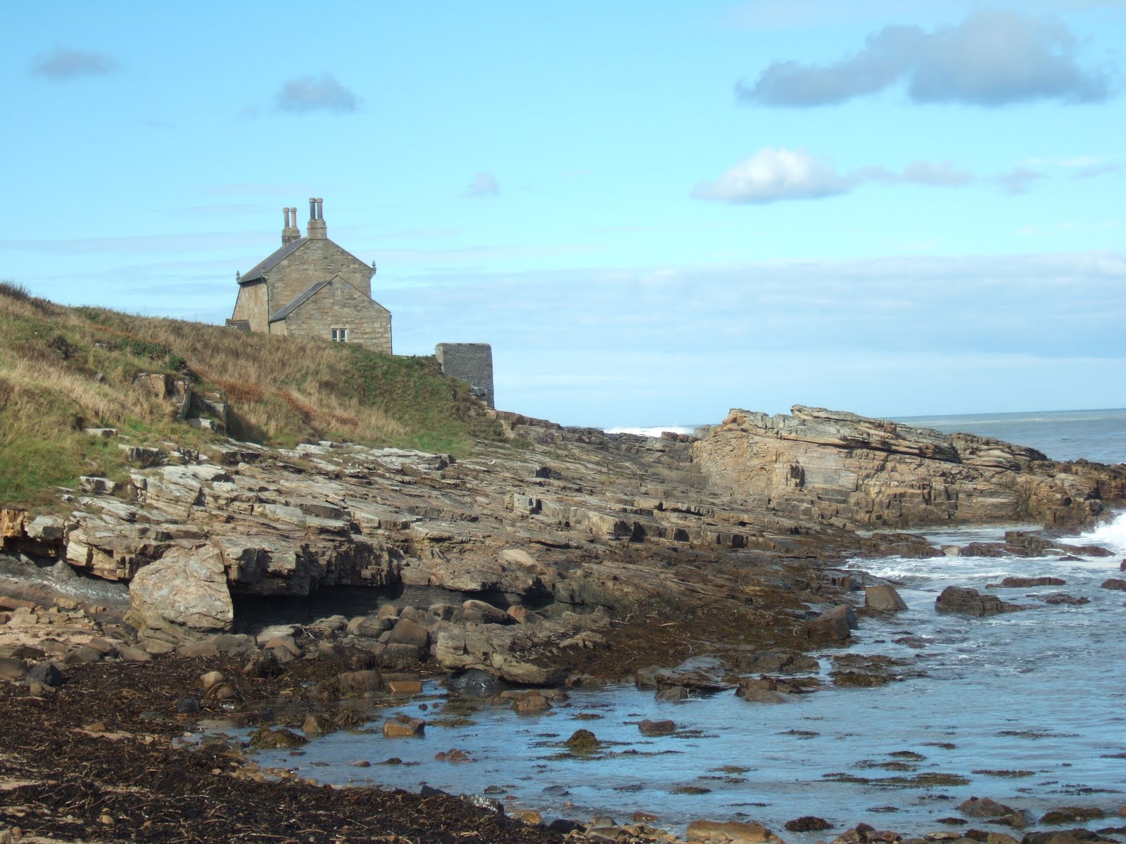
The area called the Heughs to the north of the village overlooks some inlets with sloping beds of whin sill on the coast, and mesolithic flint tools have been found here. Whin refers to the rocks themselves, made of volcanic dolomite, which were forced through layers of older rock by movement of the earth's tectonic plates, so that the Whin Sill (sill being the horizontal body of rock) always looks as if it's surprised to be amongst all the smooth land or rocks roundabout.

The castle before us was immense, its ruins a stark reminder of harder times when men needed the protection of great stone buildings. Built by the great Earl of Lancaster from 1313 -16 as a safe haven from his enemy Edward II, it never served its purpose. Lancaster was captured after a failed rebellion and beheaded, having only fled as far as Boroughbridge in Yorkshire.

Whin sill inlet, the Heughs


Once we were past the castle the crowds melted away. We wondered why
no-one else was on the beach, until we were obliged to take off our boots to ford a cold stream carving a deep unavoidable channel in the sand near Embleton village! Looking back the cliffs north-east of the castle showed the signs of summer residency to nesting seabirds, all now flown.


Dunstanburgh from the North


Leaving Embleton bay, the path continued round a headland to Newton Pools nature reserve, and in the bird hide with its view of wildfowl, in particular shoveler ducks, on the pool we enjoyed a restful interlude in a fairly demanding day. Afterwards we wandered down to Low Newton by the Sea, and patronised the trendy pub enclosed on three sides by a courtyard of pretty cottages next to the beach.


Newton Links and beach

The beach north of Low Newton, fringed by Newton Links nature reserve, is isolated and beautiful, with marram grass dunes edging the beach. It is also a long way! As we edged towards Beadnell large lesser black-backed gulls stood out from the smaller birds in a large flock of gulls feeding at the water's edge. We forded another stream then wandered tiredly into Beadnell, admiring the lobster pots and lime kiln round the harbour. Thanks to Rob as ever for his company, encouragement and car!


Lesser black-backed and common gulls on the beach south of Beadnell.

Monday 27 September 2010

St Oswald's Way Boulmer to Craster

We managed a linear walk for the next section of St Oswald's Way from Boulmer to Craster, thanks to our friends John and Kathy who brought their car too. We set off at midday, with a blue sky and an east wind whipping up big North Sea breakers. On the seashore redshanks took advantage of tiny sea creatures washed up on the incoming tide, their long (and yes red) legs giving them an ungainly, chicken-like gait. Maybe the clever creator of the scrap metal bird beside the path used them as inspiration.

Metal sculpture. Note the horseshoes.


The sea and rocks were the twin stars of this walk. White horses flecked the sea for several hundred meters from the shore, ideal for surfing. Wetsuited young men were parking their 4WDs at the car park at Howdiemont Sands and running eagerly into the sea's embrace, boards at the ready. Despite a noticeable lack of bikinied girls to admire them, some managed a fairly tolerable impersonation of Beach Boys, standing up and riding the waves far out to sea.


Sea at high tide, Howick Haven


The geology on this part of the coast changes constantly. From Boulmer to Howick coarse-grained sandstone rocks jut out into the sea, forming 'steels' or reefs. These give protection for boats in Boulmer harbour. Further up the coast, steels give way to occasional outcrops of limestone and softer sandstone; so soft in fact that Earl Grey (who steered the 1832 Reform Act through parliament and had a particular taste in tea) had a man-made swimming pool gouged out of the rock next to his 'Bathing House' at Howick, just north of the Rumbling Kern bay. We all enjoyed the bay; climbing the rocks, watching the waves rush in and crash on the seaward side or just resting and watching the world go by.


Earl Grey's bathing house, Howick


Just before reaching the bathing hut we came across Howick house mesolithic site, where from 2000 to 2002 an archaeological dig revealed a stone age structure dating 7600 years old - at that time the oldest house ever discovered in Britain. A reconstruction, at half the original size, has been constructed at the excavation site. It has a sunken floor with a central fireplace. The walls are held up with wooden stakes and turfed to keep out the cold and wind. It is estimated that the sea levels after the ice age rose by 50 meters, so this house was much further from the beach than today. I imagine their lives were nasty brutish and short, but they had a good view.


From Cullernose Point to Craster the rocks are of igneous (ie volcanic) whinstone. These form part of the Northumberland Whin Sill, whose outcrops of hard columnar basalt are to be found throughout Northumberland. The cliffs at Cullernose are the summer home of a big population of fulmars. They have flown the nest by September, leaving only guano-covered rock until the following spring. These sea cliffs are popular with climbers who like getting their feet wet!


Cullernose Point


The final section ends up in the garden of the Jolly Fisherman in Craster. More of this lovely village next time.


Friday 17 September 2010

Kielder capers


Kielder viaduct with skewed arches

We drove midweek up to Kielder castle and
village, intending to climb
Deadwater Hill behind the village. However disaster struck in the form of forgotten boots (mine!), and hill tracks in these border uplands being muddy, boggy and rocky we were obliged to lower our sights. A couple of tourist trails leading from the castle seemed more suitable for my Merrill sandals. First up was the Duchess Trail, so named because the 2nd Duchess of Northumberland liked to take her pony and trap over the pack-horse bridge at the back of the castle to amuse herself when the menfolk were away at the guns. (The castle is a former hunting lodge.)

The trail led down to the Kielder Burn. A wooden fence with observation holes gave on to another feeder, but it was the sight of a red squirrel that thrilled, scampering away before we could get out the camera.


Shortly after this the trail crossed the Duchess' humpbacked packhorse bridge, continuing on into the conifer plantations beyond before returning to the castle. These trees were planted in the 1930s from saplings brought from Aviemore in Scotland, to ensure our self-sufficiency in fuel in the event of another war. Kielder forest is the biggest man-made forest in Europe. Its conifers are often dark and sterile but this being september the forest was home to many fungi, including the beautiful but poisonous red and white fly agaric, the archetypal gnome home.


Fly agaric


After lunch we headed east to Bakethin reservoir, this time through broad-leaf woods of birch, beech, rowan, oak and hazel. The sunshine broke through the canopy and dappled the forest floor. We came upon Kielder viaduct, which took the trains of the Border County Railway across the North Tyne. The perspective of its 'skewed' arches, built at an angle to give a line of least resistance to the waters below, would challenge the artist. The path climbed up to the top of the structure, and we paused to admire the view of the castle and Deadwater Hill behind it. Closer to, a peacock butterfly enjoyed the warmth of the viaduct's lichen-covered sandstone blocks. The railway had been built to carry local iron ore and coal but its economic viability was always shaky and once these were mined out passenger and light freight were not sufficient to keep it open. The line closed in the 1950s. Nowadays a pedestrian trail runs the length of the old track along the North shore of Kielder Water.

Bakethin reservoir, a nature reserve, glimmered in the afternoon sun. It flows over a weir into Kielder water at its eastern end. Both reservoirs were the result of the flooding of the upper Tyne in 1982. A swathe of purple loosestrife stood by the water's edge and banks of bulrushes were visible on the south side of the water. Four cormorants preened themselves mid-lake, and two horses grazed the banks next to the trail, probably part of a targeted grazing programme to improve meadowland.

When I first visited Kielder, the surrounding hillsides had a raw, bare quality, with little variation of flowers and birds. Now nearly thirty years on continual improvement of the habitat has attracted greater diversity, including the return of the osprey and goshawk.


Peacock butterfly on the viaduct


Purple loosestrife next to Bakethin reservoir


'

Tuesday 7 September 2010

Once more on the way...

Well, the weather just gets better and better on St Oswald's Way, and beautiful blue sky followed us up the coast from Alnmouth to Boulmer. The path along the dunes between Alnmouth beach and golf course was lined with rose bay willow herb, in its prime in early september. No signs of trees turning colour yet, but their presence reminds us, just like the last night of the Proms, that summer is at an end.

Rose bay willow herb on the coast path


We pass the Old Battery. This grey squat stone building was used by the Percy Volunteers of Alnmouth village. Originally it had cannons facing out to sea, and the soldiers used it to practice firing them on targets in the sea. No sign of the cannons now, but it is well-preserved, with the plaque still visible: "(...) erected by Algernon, Duke of Northumberland KG (...)". I ponder the randomness of fashion in Christian names. When I read HG Wells and Oscar Wilde as a child there was inevitably a character called Algie. Now the name has disappeared, along with spats and bustles.


The path detours inland round Foxton Hall, a golf clubhouse, the beach just beyond here ending at the rocks of Seaton Point. The tide is going out, and near the caravan park at the point we see hirundines (house martins and swallows) massed on telegraph wires, a sign of their imminent migration, although on days like this they must think it's not really time to go!


House martins and swallows massed on the wires

Rounding the point, we walk by the side of Boulmer beach, and the tide reveals an enticing rocky shore which attracts many waders. We see (and hear) lots of oystercatchers, which are less black and white this time of year, some of them being juveniles and others moulting. At the pub in Boulmer we drink beer on a terrace overlooking the beach in the sunshine. How could life be better? Very close to us solitary redshanks, on disproportionately long legs, pick at marine life. It is time to return, and we walk all the way back on the beach, easily negotiable at low tide. A small flock of greenshanks, their beaks slightly upturned, feed on the tideline. I am excited by these birds of passage. They are stockier and larger than redshanks, and also rarer.

Greenshanks on Boulmer beach

Boulmer 'harbour' affords minimal protection for the small boats moored there as it is not hemmed in by land but by rocks, rather like a South Sea atoll. The rock-free entrance is so small it must be difficult to negotiate in stormy weather. There are two navigation posts on the shore just before the village. If a boat lines them up she will come through the gap in the rocks unscathed. I hope the volunteer lifeboat in Boulmer village is not used too much. Amongst these boats are two Northumbrian cobles, small inshore fishing boats with canvas covers, one brick red, the other white, at the bow.
Cobles in the bay at Boulmer
Back on Alnmouth north beach, Peter dons a pair of swimming trunks and takes his first (and probably last) swim in the North Sea this year. He emerges with a bleeding leg, a hidden underwater rock having gashed his shin. He declares the water is warm, but I
am not tempted, preferring to watch the terns doing their straight dive into the water out to sea.


Thursday 26 August 2010

St Oswald's Way 15

Golfer's bridge, Warkworth golf club.

One of the nicest days of the summer made this walk special. As we had friends with us we left one car at Alnmouth and the other near Warkworth giving a linear walk for a change. The whole of this section of St Oswald's Way passes through designated sites of Special Scientific Interest (SSSI). These take in the sea shore and beach, with the dunes and salt marshes behind. The southernmost SSSI, Warkworth Dunes and Saltmarsh stretches from the Coquet estuary at Amble northwards to Birling village. The middle SSSI named Northumberland Shore includes Birling Carrs, a small rocky headland which divides the beaches of Warkworth and Alnmouth. The furthest north, Alnmouth Salt Marsh and Dunes finishes at Alnmouth, and gives great views of the stunning salt marsh round the estuary of the river Aln.


We shared the first part of the walk with Warkworth 9-hole golf club, on Birling Links. Links, a Scottish word meaning coastal sand dunes, has become synonymous with coastal golf courses. They attract golfers because low accurate shots are needed to cope with the windy conditions. However walkers and golfers make uneasy bedfellows whether the balls are low or high, and we left the golf course with relief when the right of way turned under a pretty wooden bridge 'linking' the greens at the northern end.

Birling Carrs rocks

Walking past Birling Carrs the tide was out, and many terns were diving in the sea. About 15 ducks clustered on one of the rocks. We pondered their identity - were they eiders? In breeding plumage the male eider is unmistakable, a large, mainly black and white duck with beautiful green neck markings and a creamy-pink breast. Although the right shape and size, these ducks were disappointingly brown. A few sported white patches. However female and juvenile male eiders are brown, and white patches (on the wing) signify mature males in 'eclipse'. This happens in July and August, when the birds moult and are temporarily flightless.


Coquet island in the distance

The next part of the walk was a lazy ramble along the superb Alnmouth Bay beach, backed by dunes. The tough marram grass helps to keep these dunes from disintegrating. Resolve crumbled as we stopped many times to enjoy he summer's day. The nature reserve of Coquet Island beckoned invitingly to the south-east, another day's goal. When they were little our children called this Coconut Island, the destination of Allan Ahlberg's Master Salt the Sailor's Son.


Sea aster

Tearing ourselves away from the beach we turned inland to the salt marshes round the estuary of the Aln, The marshes are covered at high tide, and the conditions favour a distinct micro-ecology. That afternoon they were covered in sea asters and glasswort. The latter is a kind of edible samphire, which tastes like a cross between salty spinach and asparagus. Mmm. (No I didn't eat any but I have done in Cumbria.) The estuary attracts waders - there were many oystercatchers, and excitingly a flock of redshanks, which took off and wheeled low over the marsh before landing on the water's edge to feed on cockles, marine snails and other marine life. A cooperation between farmers and government has seen the dismantling of farmer's walls built to protect the fields from the tide, and the expansion of the marsh. The results are one of the most precious habitats on the coast. This is the biggest salt marsh between the Berwick and the Tees estuary.

The village of Alnmouth looks beautiful in the sun from the path round the estuary, and Tim couldn't walk past the pub courtyard serving tea and cakes. What a great way to end the day.


Alnmouth village

Friday 13 August 2010

St Oswald's Way


Last weekend saw our 13th expedition on St Oswald's Way, and we're half way there. Slow progress but we spend a lot of time routefinding, photographing and Peter in particular passes a lot of time waiting for me! Our walks tend to average 5-6 miles in two to three hours.

This time the start was about a kilometre into Rake's Lane near Acklington Park farm. We had been warned that this walk to Warkworth was a bit of a trudge across flat fields. It started to rain on cue five minutes after departure with ominous dark grey clouds to the south, thunder rumbling in the direction of Ashington. However the attractive Rake Lane (see picture) lined with meadowsweet and meadow cranesbill provided shelter from the worst of the downpour.

Reaching the end the track turned North towards New Barns over land reclaimed in the 90s from opencast mining, and we were rewarded with our first view of the sea on St Oswald's Way. The sun came out, lighting up a field of ripe wheat backed by the dunes east of Warkworth. If we hadn't been doing this walk south to north, the 'wrong' way, this moment would have been lost.

The very good cafe in Warkworth, which was closed last time we came because it was after 4.30pm was... closed again because it was Tuesday! However the village is a tourist honeypot and we went elsewhere for tea.

Returning by a different route, we set off upstream . The path alongside the Coquet has calm waters and rowing boats for hire, with Warkworth Castle to the south. It stops at Warkworth Hermitage, an ancient ruin again closed. After this the Coquet has to be crossed twice. The first was no problem, a big ugly concrete footbridge giving a dry-shod crossing. After this the right of way passed through a locked gate opening onto a field of frisky piebald horses, whose owner assured us the path was overgrown and full of brambles. Needless to say it wasn't, but it did lead down to the second river crossing, about twenty metres wide and thigh-deep. Off came the boots and then trousers. Tiny fish tickled the ankles. We were very near the craggy banks with ancient cup and ring marks.

The thought of Morwick ice-cream parlour kept us going, and once across we headed for raspberry and chocolate ices, after which we made short work of the last 2 miles, crossing the main Edinburgh to London railway taking note of the alarming signage - Take Care! Trains in excess of 100 mph on the line! The final wood which borders the Coquet at Morwick Banks had a pheasant hatchery, with high wire netting keeping the young pheasants from straying, presumably to be loosed on the guns after the glorious twelfth. No trudge this, but a walk with variety and views.

Wednesday 11 August 2010

Introducing rambling northumberland

This blog is a natural continuum of my wildlife blog, but with a wider remit, as I wanted to record not only the wildlife I see on my perambulations round the county, but also comment on routes, the aesthetic appeal of this lovely county we live in, and observations on environmental issues and even historical asides, (although having gained my least prestigious O level pass in history I cannot claim to be an expert ).

For the last year and 8 months Peter, my husband, and I have been doing short walks along the route of Saint Oswald's Way going South to North (from Heavenfield to Holy Island). As we are usually alone we do a circuit rather than a linear walk, and we try to use alternative paths to the official way on the return leg of the walk. This can often result in battling our way through rights of way which have fallen into disuse. Some of the blog entries will record our St Oswald's waying, others will reflect on shorter walks we do, usually in the local area.